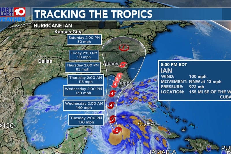
Residents of Florida are preparing for what is predicted to be a Category 4 hurricane later this week. Tropical Storm Ian is expected to continue growing stronger as it makes its way to Florida, with the storm anticipated to hit land by Thursday. Fox Weather says the storm will undergo “rapid intensification” over the next few days.
Fox News is reporting this morning that Floridians are already packing sandbags, purchasing generators, and buying dry food items in bulk. Big box stores such as Lowes are seeing people purchasing not only generators but lumber to board up windows and doors.
Currently, Ian is producing winds of approximately fifty mph; by Tuesday, the winds are predicted to surge up to 120 mph. By Wednesday, weather experts are expecting the storm to contain 140 mph winds.
Governor DeSantis has declared a state of emergency for all 67 counties in the Sunshine State ahead of the anticipated storm. Previously, DeSantis had declared an emergency for just twelve counties. He revamped the declaration as the storm shifted slightly and grew in intensification.
DeSantis issued a statement regarding the storm: “This storm has the potential to strengthen into a major hurricane, and we encourage all Floridians to make their preparations.” We are coordinating with all state and local government partners to track potential impacts of this storm.”
An emergency declaration ahead of a storm such as Ian allows for the opening up of more state resources and activates the Florida National Guard.
On Saturday evening, President Joe Biden also declared a state of emergency at the federal level. This adds federal funds to the state funds freed up by DeSantis’ state-level declaration. As a result, the Federal Emergency Management Agency has begun “pre-positioning supplies across Florida.”
However, the Biden Administration funding is for use in about twenty-four Florida counties and on two different Native American reservations.
Because the storm is still churning – and growing – in the warm waters of the Caribbean Sea, weather prognosticators are having a difficult time pinpointing exactly where landfall will take place. However, most models are pointing to a landfall in northern Florida.
John Cangialosi, a senior hurricane specialist at the National Hurricane Center, echoed this sentiment. Cangialosi says that it’s still too early to tell exactly where the hurricane will come onshore, adding that it could hit central Florida with the greatest impact or it could be a storm that impacts the entire state. Canialosi encouraged residents to stay weather-alert, keep watching weather forecasts, and prepare ahead of the storm.
Fox Weather said early Sunday that Ian should intensify and become classified as a hurricane today. A period of “rapid intensification” is considered to have taken place when the wind speeds of a storm increase by a minimum of 35 mph over a 24-hour period. Typically, the longer a storm sits over warm waters, such as those in the Gulf of Mexico and the Caribbean Sea, the stronger a storm becomes.
On Sunday morning, Tropical Storm Ian sits in the Caribbean Sea, about 300 miles south-southeast of the Cayman Islands. The storm is roughly 570 miles away from Cuba. Ian (at that time) was moving west-northwest at 14 mph.
It’s important to remember that weather forecasting models can offer several potential tracks that a storm may take, but it is difficult – particularly five days out – to say exactly where Ian will make landfall. The Hurricane Hunters with the National Weather Service have planned several data collection trips in order to better determine where Ian will come in.
A hurricane warning has been issued for the Cayman Islands and some Cuban provinces as well. In more interior provinces in Cuba, a Tropical Storm warning has been issued.
Fox Weather is predicting that the storm will have situated itself into the eastern area of the Gulf of Mexico and “in the general vicinity of the Florida Peninsula” by Wednesday.


