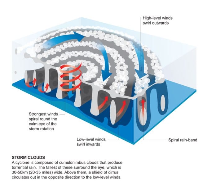
The Atlantic Ocean is currently witnessing a developing tropical wave that meteorologists believe could intensify into Tropical Storm Ernesto in the coming days. As the storm system moves across warm ocean waters, it raises concerns about potential impacts on coastal regions. The National Hurricane Center (NHC) is closely monitoring the situation and has issued updates for both residents and travelers in affected areas.
What is the status of the tropical wave developing into Tropical Storm Ernesto?
The National Hurricane Center has identified a tropical wave in the Atlantic, which exhibits characteristics that suggest it could strengthen into a tropical storm, potentially being named Ernesto. Meteorological models project that this system will gain organization as it moves westward.
Current Conditions of the Tropical Wave
As of the latest updates, the tropical wave is located approximately 1,000 miles east of the Lesser Antilles. The wave has shown signs of increasing convection, which is crucial for its development into a tropical storm. The NHC estimates a 60% chance of this system evolving into a named storm within the next 48 hours.
| Parameter | Data |
|---|---|
| Location | 1,000 miles east of the Lesser Antilles |
| Current Chance of Development | 60% within 48 hours |
| Maximum Sustained Winds | 30 mph |
| Central Pressure | 1008 mb |
Potential Track and Impact
The NHC’s forecast models suggest that the tropical wave will travel towards the west-northwest, potentially impacting the Caribbean islands and portions of the southeastern United States. Coastal areas should prepare for possible rainfall, strong winds, and elevated surf conditions if the system indeed develops into Tropical Storm Ernesto.
Forecast Track
Recent computer models indicate that the storm system may follow a path similar to the previous storms this hurricane season. Residents and forecasters will need to keep an eye on any changes in direction and intensity. The long-range track remains uncertain, but initial projections show a trajectory that could take it near Puerto Rico and the eastern Bahamas by next week.
| Date | Expected Location | Wind Speed | Chance of Development |
|---|---|---|---|
| Day 1 | Near Lesser Antilles | 30 mph | 60% |
| Day 3 | Approaching Puerto Rico | 40 mph | 70% |
| Day 5 | Near Bahamas | 50 mph | 80% |
Preparedness Measures
In light of this developing tropical wave, local agencies emphasize the importance of preparedness. Communities along the potential path of the storm are urged to take precautionary measures.
Recommendations Include:
- Create an Emergency Plan: Families should discuss evacuation routes and establish communication methods.
- Stock Up on Essentials: Prepare an emergency kit with non-perishable food, water, medications, and personal hygiene items.
- Stay Informed: Monitor local news and official announcements from the NHC for updates on the storm’s development.
- Secure Property: Residents should secure outdoor furniture, decorations, and other items that may become projectiles in high winds.
The 2023 Hurricane Season Overview
The 2023 Atlantic hurricane season has been marked by several significant storms already, and the emergence of a new system underscores the importance of vigilance during this time of year. The season typically runs from June 1 to November 30. So far, forecasters predict above-average activity, which is consistent with increased ocean temperatures and climatic factors.
Notable Stats from the 2023 Hurricane Season
| Statistic | Value |
|---|---|
| Total Named Storms | 7 |
| Hurricanes | 3 |
| Major Hurricanes (Category 3+) | 1 |
| Estimated Damages (as of Oct) | $1.5 Billion |
Conclusion
As the tropical wave continues its journey across the Atlantic, residents in potential impact zones should remain alert and take the necessary precautions. The NHC will provide ongoing updates as the situation evolves. If the system develops into Tropical Storm Ernesto, it will be the first named storm of the month, giving rise to renewed concerns about the hurricane season.
In a season already marked by activity, keeping informed and prepared remains the best course of action for those in the path of these storms. The next few days will be critical in determining whether this tropical wave will become a significant weather event.


